Flooding
Flooding is Brazil's most frequent and costly natural hazard by far — far more damaging in aggregate than the earthquakes covered in the Plates & Hazards section. In 2023 alone Brazil recorded 1,161 officially declared natural-disaster events, an average of roughly three a day, and the large majority were flood- or storm-related. Risk is concentrated in three very different settings: the seasonally flooded Amazon várzea floodplain, where high water is a predictable annual rhythm rather than a disaster; the crystalline, thin-soiled Northeast, where intense but rare rainstorms run off quickly into flash floods; and the subtropical South, where extratropical cyclones can stall over cities built on floodplains, as they did catastrophically in Rio Grande do Sul.
Where & How Often
Along the Amazon, seasonal flooding of the várzea is annual and largely beneficial, replenishing floodplain soils and fisheries. Destructive flooding is more sporadic elsewhere: flash floods strike the Northeast and the steep, urbanized hillsides of Rio de Janeiro and São Paulo during intense summer storms, while the South (Rio Grande do Sul, Santa Catarina) has been hit by repeated major river floods in 1941, 2023, and 2024, a pattern scientists link to more frequent, more intense extratropical cyclones.
Government Preparation
Brazil's early-warning backbone is Cemaden (National Center for Monitoring and Early Warning of Natural Disasters), which combines rain gauges, river sensors, and satellite data to issue risk alerts, and gave several days' warning ahead of the 2024 Rio Grande do Sul floods. But investment is skewed toward reacting rather than preventing: from 2013–2023 the federal government spent roughly R$13.3 billion responding to disaster emergencies against just R$4.9 billion on prevention, and the federal disaster-prevention budget itself fell from about R$1.9 billion in 2024 to R$1.7 billion in 2025, even as the risk of extreme rainfall grows.

Flooded streets in Porto Alegre during the record-breaking May 2024 Guaíba Lake flood.
Lesson From Two Floods
The contrast between 2024 and 2025 is Brazil's clearest evidence that flood preparedness policy works: near-identical rainfall totals produced a national tragedy the first time and a manageable emergency the second, once institutional capacity — trained civil defense staff, rehearsed evacuation routes, community-level risk communication — had been scaled up in response.
Land & River Trade Routes
Brazil moves its exports to port along two very different kinds of corridor: an extensive but geologically constrained highway network, and a growing system of river "hidrovias" (waterways) that exploit the country's low-relief interior basins.
The Routes
On land, the BR-116 — Brazil's longest highway, running roughly 4,400 km from Fortaleza in the Northeast to the Uruguayan border — and the Trans-Amazonian Highway (BR-230) form the backbone of road freight, while shorter Mercosur corridors link southern Brazil by road to Argentina, Uruguay, and Paraguay. On water, the Tietê–Paraná Waterway stretches roughly 2,400 km through São Paulo, Minas Gerais, Mato Grosso do Sul, Goiás, and Paraná, feeding the country's busiest port at Santos. In the north, the Arco Norte ("Northern Arch") links the Madeira, Amazon, Tapajós, and Tocantins Rivers through port complexes at Itacoatiara, Santarém, Belém/Barcarena, Santana, and São Luís — carrying grain out through the mouth of the Amazon instead of trucking it thousands of kilometers south to Santos.
How Geology Shapes Them
Geology dictates both routes. The escarpment of the Serra do Mar, discussed in Mountains & Volcanoes, drops almost straight from the São Paulo plateau to the coast; the BR-116's descent to the port of Santos (the "Serra do Mar system") is one of the most expensively engineered stretches of highway in Brazil, built on cut slopes that remain chronically prone to the landslides described in Weathering & Mass Wasting. The interior waterways, by contrast, are a gift of the flat, low-gradient basins of the Amazon and Paraná — but that same flatness means water levels swing enormously with the seasons: the Madeira River corridor is only reliably navigable for large barges from roughly January to August, timed to the Andean snowmelt and rainy-season pulse that raises the river enough to clear its shifting sandbars.
Advantages
River transport is dramatically cheaper per tonne-kilometer than trucking and requires far less new infrastructure than paving highways across the Amazon interior — the Arco Norte waterways alone now carry an estimated 35% of Brazil's soybean exports and 46% of its corn exports, moving Mato Grosso's harvest to the ocean without adding truck traffic to the south. Waterways also open interior agricultural frontiers that would otherwise be uneconomical to farm at export scale.
Disadvantages
Brazil uses only an estimated 30% of its waterway potential — seasonal low water strands barges for months at a time on several rivers. Overland, the BR-116's mountain descent to Santos is a chronic landslide and traffic bottleneck, and Santos itself is so overloaded (handling roughly 60% of Brazil's agricultural exports) that trucks routinely queue for days before unloading, a congestion cost passed on to every exporter.
Main Trading Partners
Brazil exported about US$400.6 billion in goods in 2024, up 18% year-on-year, leaving a trade surplus of roughly US$59.5 billion. China is by far Brazil's largest single customer and supplier.
On the import side, China's share has climbed sharply (from about 18% to 25% of Brazil's imports in recent years) while the U.S. share has slipped (17% to 15%), with Argentina, Germany, Russia, India, Italy, Mexico, France, and Japan rounding out the top ten import sources.
Oceans, Ocean Trade Routes & Islands
Ocean Currents
The warm Brazil Current flows south along nearly the entire coast, from Cabo de São Roque down to roughly 30–40°S, carrying tropical Atlantic water (19–27°C) poleward and moderating coastal temperatures along the way. Off the coast of Uruguay and Argentina it collides with the cold, northward-flowing Falklands (Malvinas) Current at the Brazil–Falkland Confluence — one of the most biologically productive convergence zones in the South Atlantic, and a major reason southern Brazil's climate is noticeably more temperate than its latitude alone would suggest.
Proximity to the Ocean
Most of Brazil's population and economic activity is concentrated within a few hundred kilometers of the Atlantic, where the ocean moderates temperature extremes relative to the continental interior. Hurricane risk has historically been treated as essentially zero: the South Atlantic almost never generates tropical cyclones, because sea-surface temperatures are typically too cool and wind shear too strong for a storm to organize. That assumption was upended in March 2004 by Hurricane Catarina — see the Hurricanes & Tsunamis section below.
Shipping Routes, Historically and Now
The same Atlantic that colonial-era sugar, gold, and enslaved-labor convoys once crossed to reach Lisbon now carries Brazil's modern trade. The Port of Santos, South America's busiest port since 2006, handled about 4.85 million TEUs of container traffic in 2024 and moves roughly 60% of the country's agricultural exports — mainly toward China and other Asian markets (often routed via the Panama Canal or around the Cape of Good Hope), as well as the United States and Europe. Because Brazil has a long, uninterrupted Atlantic coastline rather than being landlocked, essentially none of its trade needs to transit a neighboring country to reach the sea, in sharp contrast to landlocked nations like Bolivia or Paraguay, which depend on river corridors or foreign ports.
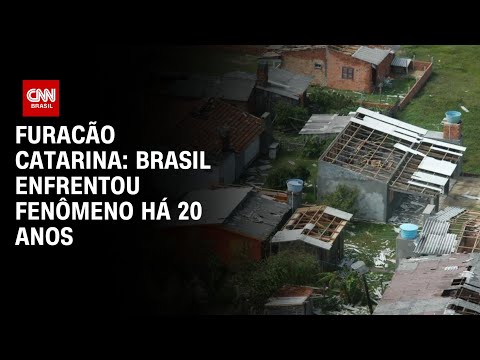 ►
Furacão Catarina: Brasil enfrentou fenômeno há 20 anos
CNN Brasil — watch on YouTube ↗
►
Furacão Catarina: Brasil enfrentou fenômeno há 20 anos
CNN Brasil — watch on YouTube ↗
A 20th-anniversary news retrospective on Hurricane Catarina, the only confirmed hurricane ever recorded in the South Atlantic. Opens on YouTube in a new tab.
Islands

Fernando de Noronha
A volcanic archipelago of 21 islands and islets roughly 350 km off the Northeast coast, and a UNESCO World Heritage marine site. Tourism is essentially its entire economy — visitor numbers are capped and a daily environmental preservation fee is charged to protect the reefs and nesting sea turtles the islands are known for.
Marajó & the Coastal Islands
At the mouth of the Amazon, Ilha de Marajó — built from river sediment rather than volcanic rock — is the largest fluvial-marine island on Earth and supports water-buffalo ranching found almost nowhere else in Brazil. More broadly, Brazil's coast is fringed by more than 3,000 islands and islets, which shelter fishing communities, host ports, and anchor much of the country's coastal tourism economy.
Coastlines
Brazil has a long Atlantic coastline of roughly 7,491 km — the 16th-longest in the world — and its shape is anything but uniform. In the Southeast, the coast is irregular and rocky, where granite spurs of the Serra do Mar plunge straight into the sea to form dramatic headlands, bays, and natural harbors like Rio de Janeiro's Guanabara Bay. Further south, the shoreline straightens into vast, regular sandy stretches — Praia do Cassino in Rio Grande do Sul runs roughly 212 km without a break, one of the longest continuous beaches on Earth. In the north, low-lying, muddy shores fringed by mangrove forests dominate around the Amazon delta and Maranhão, while offshore near Bahia the Abrolhos Bank hosts the largest and richest coral reefs in the South Atlantic.
Positive Effects
Deep natural harbors like Guanabara and Santos Bay support major ports without extensive dredging; long sandy beaches drive a tourism economy worth billions of dollars annually; and mangrove and reef systems function as nurseries for the fisheries the coastal population depends on.
Negative Effects
The long sandy stretches of the South and Northeast are highly vulnerable to erosion from sea-level rise and storm surge, threatening beachfront infrastructure. Mangrove clearance for urban and port expansion removes the natural buffer that would otherwise absorb storm energy and filter runoff before it reaches the sea.
Hurricanes & Tsunamis
Brazil sits in a part of the Atlantic that almost never produces either hazard directly — but "almost never" is not "never."
Tsunamis are rarer still, because Brazil's Atlantic coast is a passive margin with no nearby subduction zone capable of generating one locally (see Plates & Hazards). The one documented case of a tsunami reaching Brazil came from across the ocean: the 1755 Lisbon earthquake sent a trans-Atlantic tsunami that reached Recife roughly seven hours later, with colonial-era letters describing unusually large waves striking the shore — a reminder that even a country with no local tsunami source is not entirely insulated from the hazard.
Sources & References (APA)
- ACAPS. (2024, May 14). Briefing note: Brazil — Floods in Rio Grande do Sul. ReliefWeb. reliefweb.int
- Wikipedia contributors. (2025). 2024 Rio Grande do Sul floods. Wikipedia. en.wikipedia.org
- World Resources Institute. (2024). After Brazil's floods, how to build resilience. wri.org
- UNDRR. (2025). Brazil: Resilient recovery through flood management collaboration. undrr.org
- Guia Marítimo. (2024). Hidrovia Paraná–Tietê: corredor logístico que move o agro e a indústria brasileira. guiamaritimo.com.br
- Mongabay. (2020). Multiplying Amazon river ports open new Brazil-to-China commodities routes. news.mongabay.com
- Liberal Amazon. (2023). Brazil uses only 30% of the waterway economic potential. liberalamazon.com
- Statista. (2025). Brazil: Main trade partner countries, 2024. statista.com
- World Integrated Trade Solution (WITS). (2025). Brazil trade summary. World Bank. wits.worldbank.org
- Britannica. (2024). Brazil Current. britannica.com
- Wikipedia contributors. (2025). South Atlantic Current. en.wikipedia.org
- Wikipedia contributors. (2025). Hurricane Catarina. en.wikipedia.org
- NOAA Atlantic Oceanographic and Meteorological Laboratory. (2014). 10th anniversary of Cyclone Catarina. aoml.noaa.gov
- NASA Earth Observatory. (2004). "Hurricane" Catarina hits Brazil. earthobservatory.nasa.gov
- usamapxl. (2024). Brazil coastline length, geography and coastal ecosystems. usamapxl.com
- MDPI Water. (2021). Fernando de Noronha Archipelago (Brazil): A coastal geopark proposal to foster the local economy, tourism and sustainability. mdpi.com
- Britannica. (2024). Fernando de Noronha Island. britannica.com
- Latin American Cargo. (2024). Santos Port — Everything you need to know before shipping. latinamericancargo.com
- CNN Brasil. (2024, March 28). Furacão Catarina: Brasil enfrentou fenômeno há 20 anos [Video]. YouTube. youtube.com
- Images: Wikimedia Commons — Porto Alegre flood, 2024, Praia da Atalaia, Fernando de Noronha.