Weathering & Mass Wasting
Straddling the equator to the subtropics, Brazil's warm, humid climate makes chemical weathering — especially hydrolysis, and in its scattered limestone and quartzite terrains, carbonation — far more aggressive than mechanical weathering. Pair that with the steep, saturated escarpments walling the coast off from the interior, and Brazil becomes one of the most landslide-prone countries on Earth that sits nowhere near a plate boundary.
Hydrolysis & Laterization
Across the ancient granites and gneisses of the Brazilian Shield, hydrolysis breaks feldspar down into clay minerals, leaching away silica and concentrating iron and aluminum oxides into thick, red lateritic soil profiles. These deeply weathered mantles can run tens of meters deep — fertile when intact, but dangerously unstable once saturated on a slope.
Carbonation & Karst
In Chapada Diamantina, Bahia, low-pH groundwater dissolves fractures in carbonate and quartz-metasandstone rock, carving out more than 1,600 recorded caves — including Toca da Boa Vista, South America's largest cave system with 114 km of surveyed passage — through carbonation and the closely related dissolution of silicate mineral cement.
The catastrophe directly led to the creation, later in 2011, of Cemaden (Centro Nacional de Monitoramento e Alertas de Desastres Naturais) — a federal agency that maps landslide-risk zones and issues rainfall-triggered early warnings for over a thousand vulnerable municipalities. But funding and follow-through remain uneven: in February 2022, an equally extreme storm over Petrópolis triggered more than 250 landslides and killed at least 234 people, even though the city's hazard zones had already been mapped years earlier — a reminder that Brazil's mass-wasting risk is now well understood scientifically, yet still only partially managed on the ground.
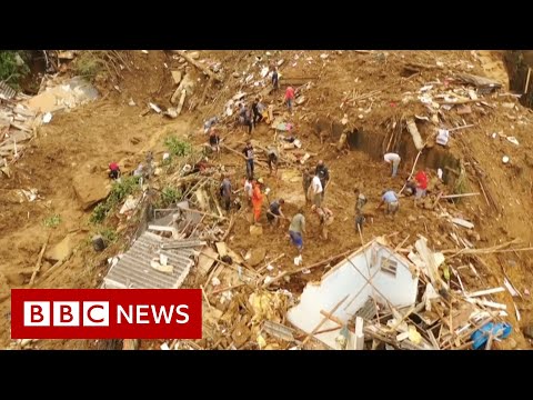 ►
Deadly landslides wreak havoc in Petrópolis, Brazil
BBC News — watch on YouTube ↗
►
Deadly landslides wreak havoc in Petrópolis, Brazil
BBC News — watch on YouTube ↗
Footage of the February 2022 mudslides that struck the same Serra do Mar escarpment region devastated a decade earlier. Opens on YouTube in a new tab.
Sources & References
- Weathering & Mass Wasting: Região Serrana 2011 Landslides — Impact on Public Mental Health System (PLOS Currents Disasters); Deadly disasters in SE South America: the 2022 Petrópolis flash floods and landslides (NHESS); Toca da Boa Vista — Geological and Paleontological Sites of Brazil; Caves, Karst Features and Speleological Heritage in Chapada Diamantina.
- Video: "Deadly landslides wreak havoc in Petrópolis, Brazil" (BBC News).